The following document is version 6.0 of the DHS GeoCONOPS, formerly known as the Federal Interagency Geospatial Concept of Operations.
Homeland Security Geospatial Concept of Operations (GeoCONOPS) Version 6
- 226 pages
- June 2014
- 4.6 MB
![]()
This Homeland Security (HLS) Geospatial Concept of Operations (GeoCONOPS) has been developed as a strategic starting point for understanding how the coordination of Homeland Security and Homeland Defense (HD) geospatial activities can be improved at the federal level. The intended audience for this document is the full geospatial community supporting the missions of the federal government under the National Response Framework (NRF) and Presidential Policy Directive 8 (PPD-8). This includes the stakeholders and actors representing the Emergency Support Functions (ESFs), the Joint Field Offices (JFO), Federal Operations Centers, the disaster preparedness exercise and evaluation community, and those involved in other NRF missions. Individuals representing these groups and activities have been extensively engaged in providing input for this document.
When finalized, this GeoCONOPS is intended to serve as a guide to federal departments and agencies providing geospatial support under the Stafford Act. The Stafford Act describes the programs and processes by which the federal government provides disaster and emergency assistance to state and local governments, tribal nations, eligible private nonprofit organizations, and individuals affected by a declared major disaster or emergency.
…
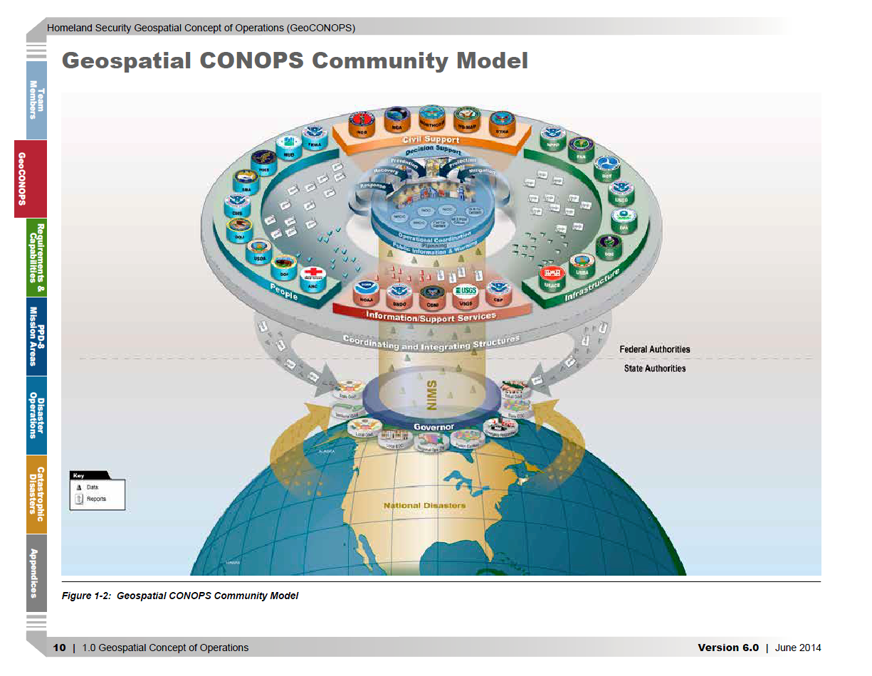
The Homeland Security GeoCONOPS is intended to identify and align the geospatial resources that are required to support the NRF, ESF, and supporting federal mission partners1 all in coordination with PPD-8 direction. Through the development of the document, end users supporting homeland security and emergency management operations will be better served with authoritative and expedited coordination mechanisms that facilitate geospatial information sharing. By defining these mechanisms and authorities, this GeoCONOPS aims to reduce redundancy and confusion and ensure efficient access to geospatial information for incident management.
1.2 Overview
DHS is relying more often and more broadly on geospatial information technology to collect and analyze key situational awareness data for its emergency response missions. According to the National Strategy for Homeland Security and DHS’s mission statement: homeland security covers prevention, protection, mitigation, response, and recovery. Geospatial products and intelligence play a key role in the Department’s preparation for disasters and its response to them; they are used to help assess damage, aid in search and rescue (SAR), remove debris, and support incident management.
The Geospatial Management Office (GMO) serving the DHS Chief Information Office, was established by the Intelligence Reform and Terrorism Prevention Act of 2004 (Title VII, Subtitle B, Section 8201, Homeland Security Geospatial Information). Through its implementation of DHS Management Directive 4030, the GMO exercises executive leadership in establishing DHS geospatial information technology programs, directives, and initiatives and provides oversight for the integration of geospatial data and technology. It serves as the principal office to facilitate all interagency activities relating to domestic geospatial and remote sensing (RS) data to support the needs of homeland security-related intelligence, law enforcement, environmental, scientific, and emergency response requirements. The GMO must develop requirements and processes for access to common operating data used by components and provide guidance to other federal departments and agencies that are supporting and executing homeland security and emergency management operations.
Geospatial technology provides a significant role in incident management. Its uses today include disaster early warning and mitigation, border monitoring, criminal investigations, public health protection, and Critical Infrastructure (CI) oversight. In recent years, federal mission partners have been operating with minimal formal guidance or direction on how to conduct geospatial support to the emergency response and homeland security operating regimes, relying instead on ad hoc coordination.
As a result, geospatial efforts in support of incident management have frequently been slow to start or have been completely unavailable immediately following a disaster, leaving the “full power” and benefits of geospatial technology unrealized. The development of the HLS GeoCONOPS for homeland security and emergency management operations ensures that timely and accurate geospatial data, models, and simulation analysis are shared across the entire geospatial community, resulting in better informed decision making across all phases of an incident.
…