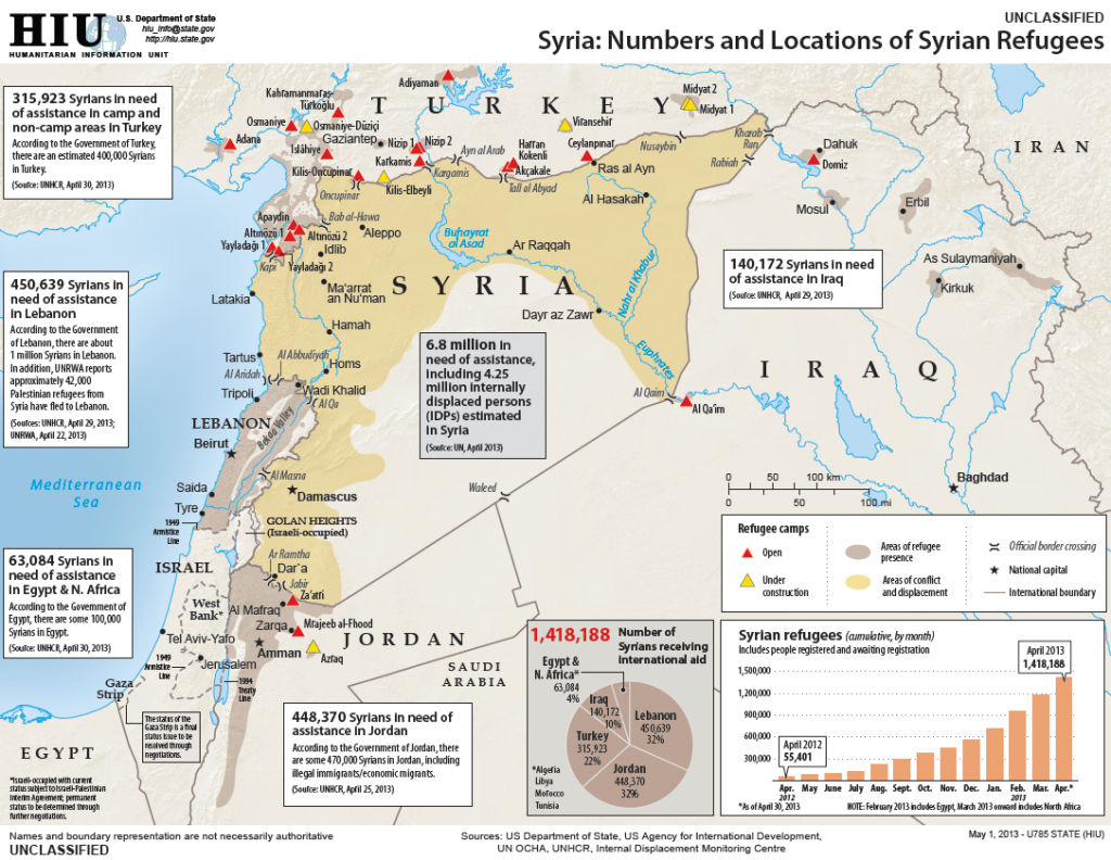
November 2012
Number of shelters: 5,163
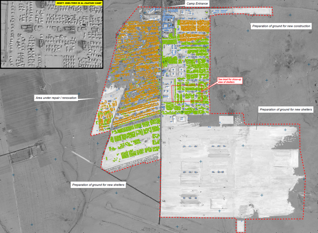 This map illustrates satellite-detected shelters and other buildings at the Al Zaatari refugee camp in Mafraq Governatorate, Jordan. As of 15 November 2012 a total of 5,163 shelters were detected as well as 499 infrastructure and support buildings within the 216 hectares of the camp. The number of shelters has thus increased by about 2,400 since the previous UNITAR/UNOSAT assessment of the camp which used a satellite image from 3 September 2012, indicating the number of camp inhabitants have likely doubled since that date. In addition, numerous areas of expansion are also visible in the image as of 15 November 2012, indicating preparations are underway to accommodate similarly increased numbers of refugees in the near future. This is a preliminary analysis and has not yet been validated in the field. Please send ground feedback to UNITAR/UNOSAT |
January 2013
Number of shelters: 11,966
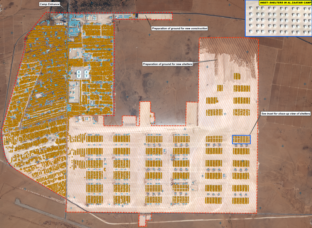 This map illustrates satellite-detected shelters and other buildings at the Al Zaatari refugee camp in Mafraq Governorate, Jordan. As of 3 January 2013 a total of 11,966 shelters were detected as well as 866 infrastructure and support buildings within the 314 hectares of the camp. The number of shelters has thus increased by about 6,803 since the previous UNITAR/UNOSAT assessment of the camp which used a satellite image from 15 November 2012, indicating the number of camp inhabitants have almost doubled since that date. In addition areas of expansion are also visible in the image as of 3 January 2013, indicating preparations are underway to accommodate similarly increased numbers of refugees in the near future. This is a preliminary analysis and has not yet been validated in the field. Please send ground feedback to UNITAR/UNOSAT. |
February 2013
Number of shelters: 18,169
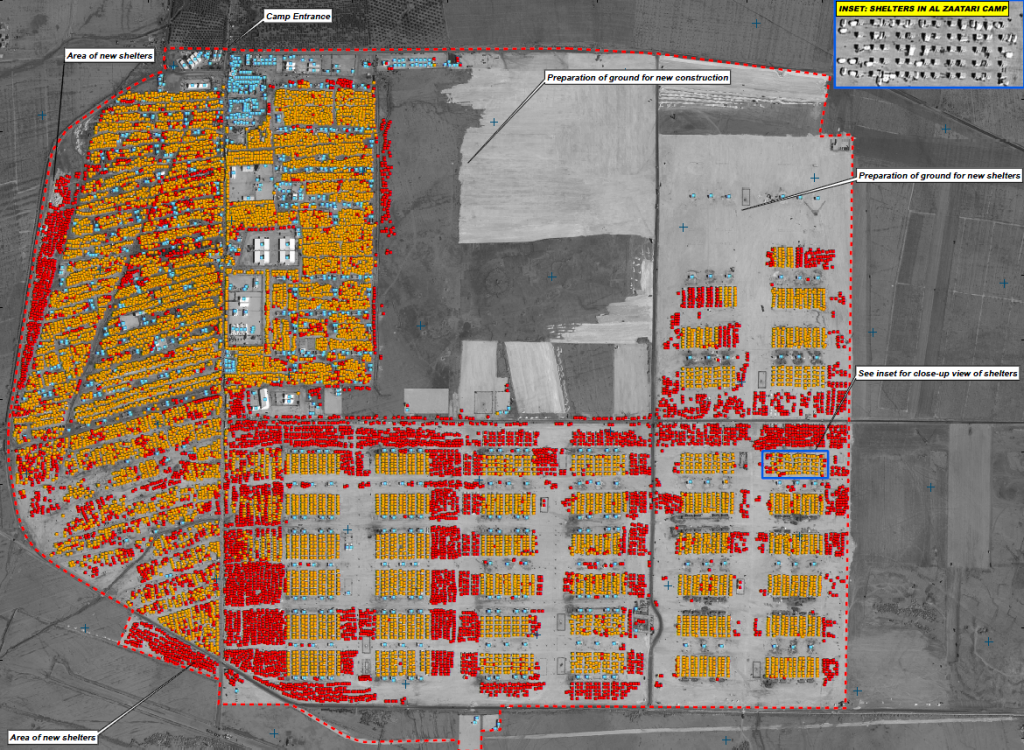 This map illustrates satellite-detected shelters and other buildings at the Al Zaatari refugee camp in Mafraq Governorate, Jordan. As of 3 February 2013 a total of 18,169 shelters were detected as well as 892 infrastructure and support buildings within the 405.19 hectares of the camp. The number of shelters has thus increased by about 6,203 since the previous UNITAR/UNOSAT assessment of the camp which used a satellite image from 3 January 2013. This indicates a 66% increase in the number of shelters between 3 January and 3 February 2013. In addition areas of expansion are also visible in the image as of 3 February 2013, indicating preparations are underway to accommodate increased numbers of refugees in the near future. This is a preliminary analysis and has not yet been validated in the field. Please send ground feedback to UNITAR/UNOSAT. |
March 2013
Number of shelters: 26,242
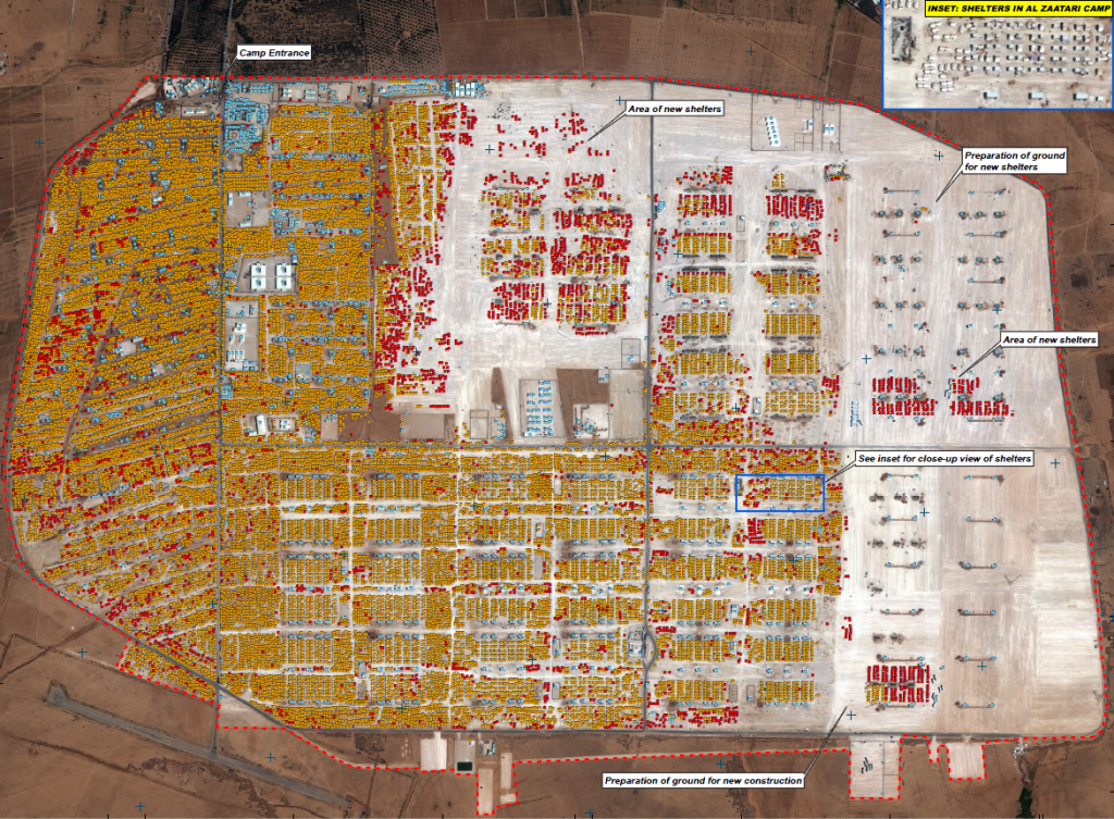 This map illustrates satellite-detected shelters and other buildings at the Al Zaatari refugee camp in Mafraq Governorate, Jordan. As of 14 March 2013 a total of 26,242 shelters were detected as well as 1,182 infrastructure and support buildings within the 531.21 hectares of the camp. The number of shelters has thus increased by about 1,563 since the previous UNITAR/UNOSAT assessment of the camp which used a satellite image from 26 February 2013. This indicates a 6.3% increase in the number of shelters between 14 March 2013 and 26 of February 2013. In addition areas of expansion are also visible in the image as of 14 March 2013, indicating preparations are underway to accommodate increased numbers of refugees in the near future. This is a preliminary analysis and has not yet been validated in the field. Please send ground feedback to UNITAR/UNOSAT. |
April 2013
Number of shelters: 25,378
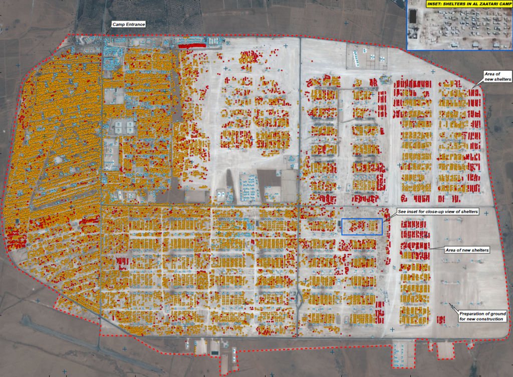 This map illustrates satellite-detected shelters and other buildings at the Al Zaatari refugee camp in Mafraq Governorate, Jordan. As of 15 April 2013 a total of 25,378 shelters were detected as well as 1,451 infrastructure and support buildings within the 531.44 hectares of the camp. Between 31 March 2013 and 15 April 2013, a total of 4,288 shelters closed or were moved, and a total of 4,555 shelters were constructed, and the number of shelters has thus increased by about 62 since the previous UNITAR/UNOSAT assessment. This indicates a 0.2% increase in the number of shelters between 31 March and 15 April 2013. In addition areas of expansion are also visible in the image as of 15 April 2013, indicating preparations are underway to accommodate increased numbers of refugees in the near future. This is a preliminary analysis and has not yet been validated in the field. Please send ground feedback to UNITAR/UNOSAT. |
May 2013
Number of shelters: 28,243
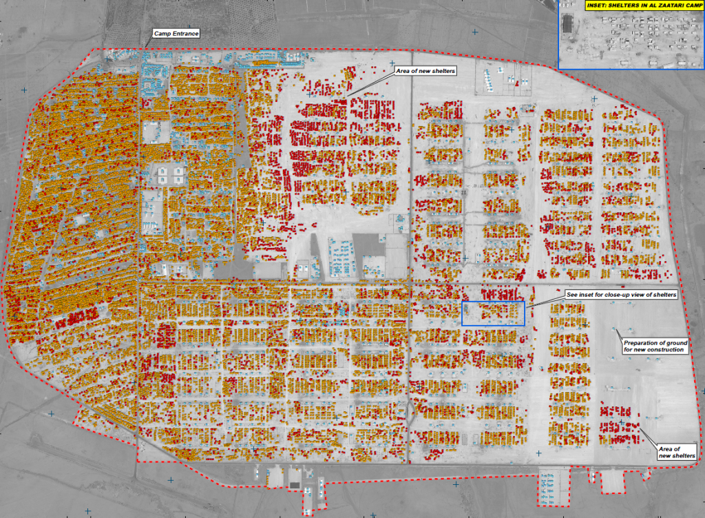 This map illustrates satellite-detected shelters and other buildings at the Al Zaatari refugee camp in Mafraq Governorate, Jordan. As of 4 May 2013 a total of 28,243 shelters were detected as well as 1,662 infrastructure and support buildings within the 530.95 hectares of the camp. Between 15 April 2013 and 4 May 2013, a total of 3,754 shelters closed or were moved, and a total of 6,545 shelters were constructed, and the number of shelters has thus increased by about 2,791 since the previous UNITAR/UNOSAT assessment. This indicates a 11.3% increase in the number of shelters between 15 April and 4 May 2013. In addition areas of expansion are also visible in the image as of 4 May 2013, indicating preparations are underway to accommodate increased numbers of refugees in the near future. This is a preliminary analysis and has not yet been validated in the field. Please send ground feedback to UNITAR/UNOSAT. |

