
The following map and satellite photos depict refugee camps in Syria, Jordan and Turkey fleeing the ongoing conflict in Iraq and Syria. It is estimated that over four million people have been displaced according to a U.N. report released in early July. A ZIP archive (7.8 MB) containing all five documents is also available.
| Southern Syria: Population & Internally Displaced Persons July 2015 | Download |
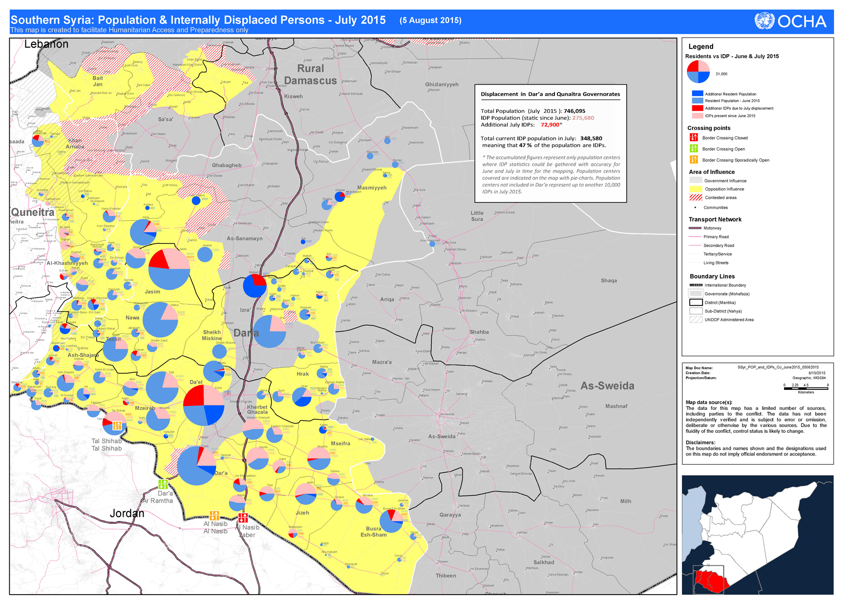 Displacement in Dar’a and Qunaitra Governorates Displacement in Dar’a and Qunaitra GovernoratesTotal Population (July 2015 ): 746,095 IDP Population (static since June): 275,680 Additional July IDPs: 72,900* Total current IDP population in July: 348,580 meaning that 47 % of the population are IDPs. |
|
| Bab Al Salame IDP Camp in A’Zaz District, Syria as of 05 June 2015 | Download |
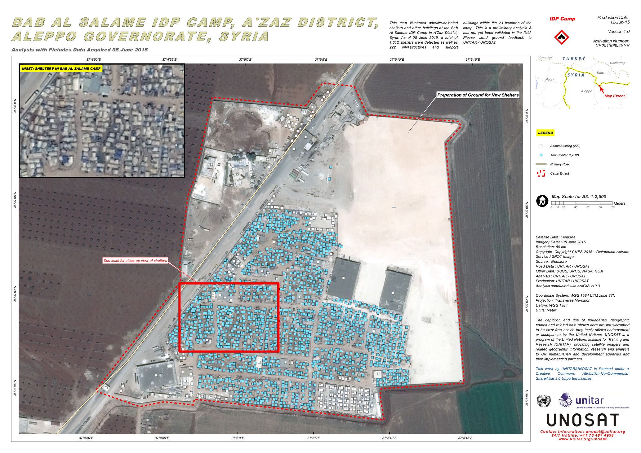 This map illustrates satellite-detected shelters and other buildings at the Bab Al Salame IDP Camp in A’Zaz District, Syria. As of 05 June 2015, a total of 1,612 shelters were detected as well as 222 infrastructures and support buildings within the 23 hectares of the camp. This is a preliminary analysis & has not yet been validated in the field. Please send ground feedback to UNITAR / UNOSAT. This map illustrates satellite-detected shelters and other buildings at the Bab Al Salame IDP Camp in A’Zaz District, Syria. As of 05 June 2015, a total of 1,612 shelters were detected as well as 222 infrastructures and support buildings within the 23 hectares of the camp. This is a preliminary analysis & has not yet been validated in the field. Please send ground feedback to UNITAR / UNOSAT. |
|
| Oncunipar Refugee Camp in Merkez District, Kilis Province, Turkey as of 05 June 2015 | Download |
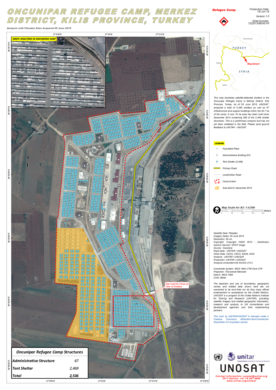 This map illustrates satellite-detected shelters in the Oncunipar Refugee Camp in Merkez District, Kilis Province, Turkey. As of 05 June 2015, UNOSAT analyzed a total of 2,469 shelters as well as 67 infrastructure and support buildings within the 40.7 ha of the camp. A new 10 ha area has been built since December 2014 containing 506 of the 2,469 shelter structures. This is a preliminary analysis and has not yet been validated in the field. Please send ground feedback to UNITAR – UNOSAT. This map illustrates satellite-detected shelters in the Oncunipar Refugee Camp in Merkez District, Kilis Province, Turkey. As of 05 June 2015, UNOSAT analyzed a total of 2,469 shelters as well as 67 infrastructure and support buildings within the 40.7 ha of the camp. A new 10 ha area has been built since December 2014 containing 506 of the 2,469 shelter structures. This is a preliminary analysis and has not yet been validated in the field. Please send ground feedback to UNITAR – UNOSAT. |
|
| Sujjo IDP Camp in A’Zaz District, Syria as of 05 June 2015 | Download |
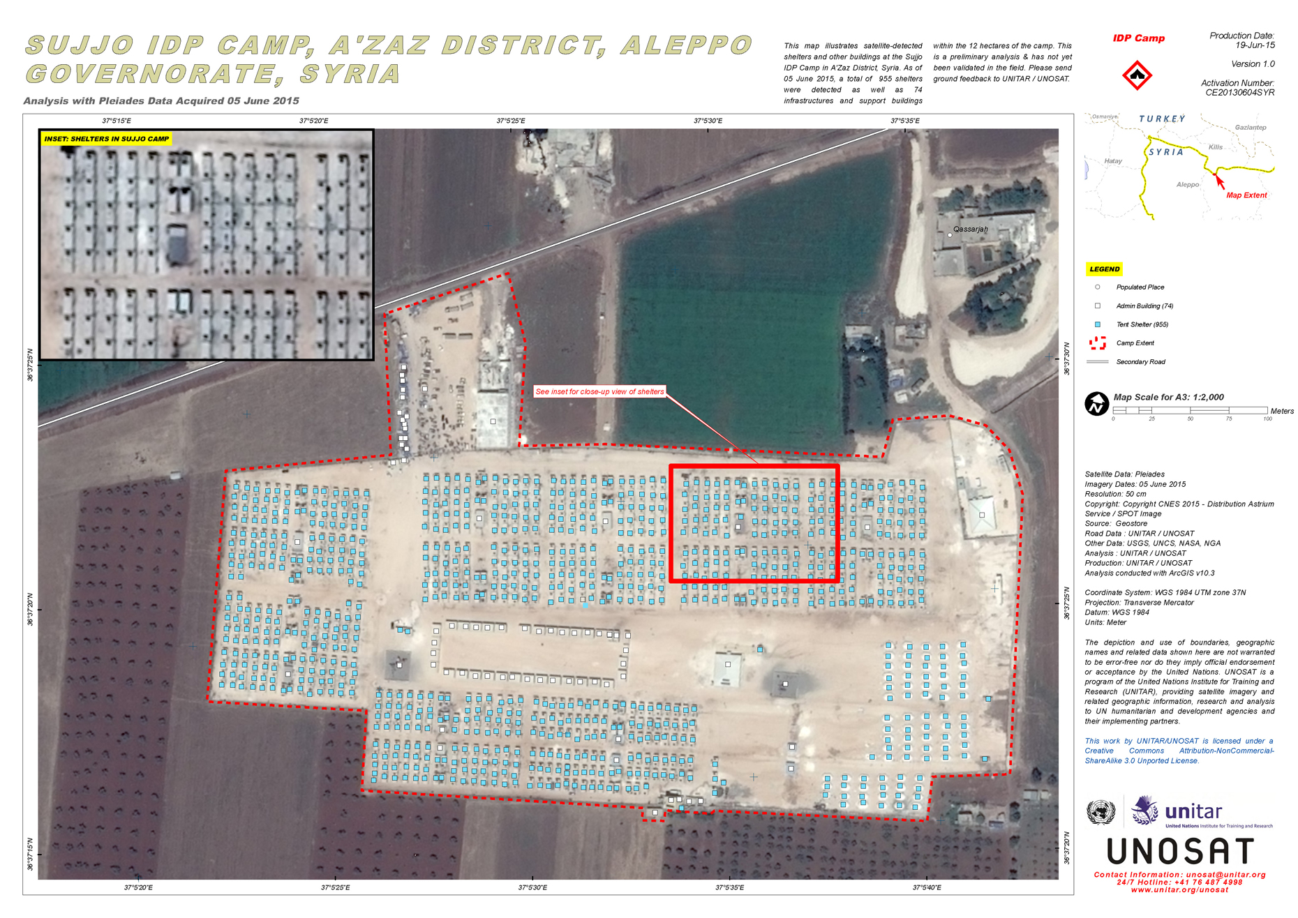 This map illustrates satellite-detected shelters and other buildings at the Sujjo IDP Camp in A’Zaz District, Syria. As of 05 June 2015, a total of 955 shelters were detected as well as 74 infrastructures and support buildings within the 12 hectares of the camp. This is a preliminary analysis & has not yet been validated in the field. Please send ground feedback to UNITAR / UNOSAT. This map illustrates satellite-detected shelters and other buildings at the Sujjo IDP Camp in A’Zaz District, Syria. As of 05 June 2015, a total of 955 shelters were detected as well as 74 infrastructures and support buildings within the 12 hectares of the camp. This is a preliminary analysis & has not yet been validated in the field. Please send ground feedback to UNITAR / UNOSAT. |
|
| Al Zaatari refugee camp in Mafraq Governorate, Jordan as of 06 July 2014 | Download |
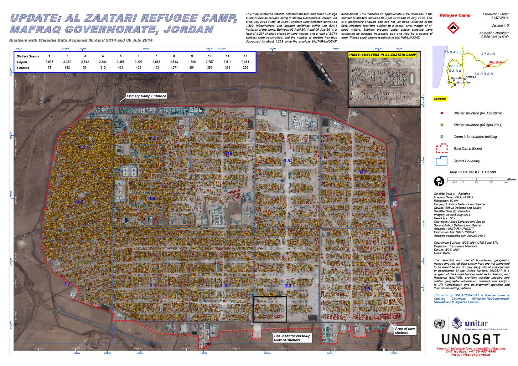 This map illustrates satellite-detected shelters and other buildings at the Al Zaatari refugee camp in Mafraq Governorate, Jordan. As of 06 July 2014 a total of 29,982 shelters were detected as well as 1,880 infrastructure and support buildings within the 534.4 hectares of the camp. Between 06 April 2014 and 06 July 2014, a total of 4,257 shelters closed or were moved, and a total of 2,774 shelters were constructed, and the number of shelters has thus decreased by about 1,298 since the previous UNITAR/UNOSAT assessment. This indicates an approximate 4.1% decrease in the number of shelters between 06 April 2014 and 06 July 2014. This is a preliminary analysis and has not yet been validated in the field; structure locations subject to a spatial error margin of +/- three meters. Shelters grouped under plastic sheeting were estimated by average household size and may be a source of error. Please send ground feedback to UNITAR/UNOSAT. This map illustrates satellite-detected shelters and other buildings at the Al Zaatari refugee camp in Mafraq Governorate, Jordan. As of 06 July 2014 a total of 29,982 shelters were detected as well as 1,880 infrastructure and support buildings within the 534.4 hectares of the camp. Between 06 April 2014 and 06 July 2014, a total of 4,257 shelters closed or were moved, and a total of 2,774 shelters were constructed, and the number of shelters has thus decreased by about 1,298 since the previous UNITAR/UNOSAT assessment. This indicates an approximate 4.1% decrease in the number of shelters between 06 April 2014 and 06 July 2014. This is a preliminary analysis and has not yet been validated in the field; structure locations subject to a spatial error margin of +/- three meters. Shelters grouped under plastic sheeting were estimated by average household size and may be a source of error. Please send ground feedback to UNITAR/UNOSAT. |
|